
The Groton Lakes Association is a non-profit organization devoted to the improvement and preservation of the lakes in Eastern Groton.
Located in Groton, Massachusetts, the GLA works closely with local, state, and federal agencies, as well as other community organizations to develop and implement programs, strategies, and ideas which will preserve the lakes for both native wildlife and recreational use, thereby enhancing the quality of life in our local watershed.
About the Lakes
The main inlet to Lost Lake/Knops Pond is Martins Pond Brook; there is an unnamed stream that flows from Indian Hills area and into Lost Lake; underground springs have also been mentioned over the years.
Fishing Access The only legal public access for fishing is via boats launched from the state owned public boat launch off Pine trail at the northern end of Lost Lake. The area surrounding Sargisson Beach on Knops Pond is frequented by fishermen but it is not considered a legal access for fishermen.
Legal Public Access Via the boat launch - open to the public with no restrictions. The boat launch is owned by the Department of Public Access board. Unfortunately this access is a source of weeds coming into and going from Lost Lake and Knops Pond because it is neither monitored nor managed by the state or town.
Water Supply Areas Most houses on the lakes depend upon shallow (point or dug) wells or drilled wells for their water. There are few residences at the northern tip of Lost Lake that have town water. Note that Lost Lake drains from the dam into Whitney Pond which has a town well along its edge. This well is a secondary water source to a well located at the edge of Baddacook Pond.
Water Quality In order to ensure environmental safety, regular water quality tests should be performed at least yearly by competent authority or if not possible by some lay individuals who will have been trained to execute such a task in the best conditions possible. The water clarity should also be monitored on a regular basis (yearly or more often in case of adverse climatic conditions).
Dam and Water Level Management Practice The lakes are fed by underground springs as well as two streams (Martins Pond Brook and an unnamed stream). There is a man-made dam at the northern end of Lost Lake. The water level of both Lost Lake and Knops Pond is controlled by inserting or removing boards from this dam. Responsibility for maintaining the boards in the dam resides with the Town of Groton Highway Department. The lake level is lowered each year beginning in mid to late October and returning to full pool level in April. The lowering of the lakes by about thirty inches during the winter months is essential to prevent ice from damaging the dam and shoreline property. The lowering of the water level protects the docks of lake shore residents and allows these residents to repair the walls along their shoreline.
Description of the Lakes
This 204-acre impoundment is actually three ponds that were bound into one when water levels were raised by a dam. The long northern basin is still referred to as Lost Lake. The water is clear, and in the huge expanses of shallow water aquatic vegetation is very abundant. The shoreline is about 70 percent developed with year round and seasonal homes. Fishing, boating water skiing and swimming are all popular activities at this lake.
Swimming
Swimming used to be a popular activity but has decreased significantly as the result of severe weed infestation. There is a public beach maintained on the lake, a large institutional beach (Grotonwood), a "locals" beach, and numerous small private beaches.
Sargisson Beach - a public beach located on the southeast shore of Knops Pond. This beach was opened for use during the summer months, and swimming lessons were conducted there. Unfortunately, budget considerations of the Town of Groton closed this beach a few years ago.
Position: 42°35.16'N 71°31.11'W
Nearest Address: 155 Whiley Road Groton, MA 01450
Grotonwood Beach - located on the western shore of Lost Lake, and is used by the guests of the camp. See the box below for details.
Position: 42°35.75'N 71°31.70'W
Nearest Address: 167 Prescott Street, Groton, MA 01450
Baby Beach - small beach is located at the northern end of Lost Lake near the outlet structure. It has limited access and is used only for local resident bathing. A floating dock usually is placed just offshore during the summer.
Position: 42°36.00'N 71°31.09'W
Nearest Address: 29 Baby Beach Road, Groton, MA 01450
Invasive Weeds
Unfortunately Lost Lake and Knops Pond are suffering from a severe infestation of nonnative invasive weeds that are killing off native species thereby destroying the lakes biodiversity and habitat diversity. Click below for the complete Resource Management Plan:
STATISTICS
Skill Level: Flat water
Estimated Time: 2.5 hour
Perimeter: 7.1 miles
USGS Map: Ayer, MA
Physical Features:
- Area: 204 acres
- Max depth: 30 feet
- Average Depth: 10 feet
- Transparency: (clear) feet
- Terrain Type: Homes, Conservation Land, Woods,
Fish Population
- Last survey: Unknown
- 12 Species: Largemouth bass, chain pickerel, yellow perch, bluegill, pumpkinseed, brown bullhead, yellow bullhead, golden shiner and creek chubsucker. This pond is stocked every spring and fall with ample numbers of rainbow, brown and/or brook trout.
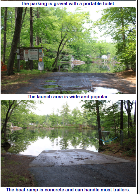
Knops Pond Boat Ramp
Position: 42°26.26'N 71°20.13'W
Boat Launch:
Access is provided by a concrete ramp owned by the Public Access Board and located off Whiley Road / Lost Lake Drive at the northeastern end of the pond. There is adequate parking for ten vehicles and the ramp is suitable for small trailer boats, car top boats and canoes.
Nearest Launch Address:
74 Pine Trail, Groton, MA 01450
